
Wherobots Introduces RasterFlow, a Major Step Forward in Earth Intelligence That Makes Complex Earth Observation Data Simple and AI-Ready
 London police to extend use of live facial recognition, drones

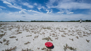 Europe swelters under record-breaking heatwave

 Iran says deal to end Mideast war 'declaration of US defeat'
 S.Korea chip giant SK hynix seeks $29 bn in Nasdaq listing: regulatory filing
 'Pragmatists' vs 'hardliners': Is Iran split over US deal?

 H5 bird flu detected in second Australia state

 Brazil aim for last 32 as World Cup goes into hectic phase

 Necessity drives gold miners in DR Congo's Ebola epicentre

 Japan PM heckled at WWII memorial

 Hanoi residents mount silent protest over home demolitions

 US Congress passes symbolic Iran war rebuke to Trump

 Bolivia's government is 'stoking a civil war,' ex-president Evo Morales tells AFP

 Fans in China put politics aside to cheer Japan at World Cup

 Geopolitics and AI in spotlight at China's 'Summer Davos'

 Race for robotaxi market arrives in London

 Moana Pasifika axed from Super Rugby after rescue talks fail

 Golden Boot battle steals the show at World Cup

 Red or green? For Brazil, the politics of World Cup kits matter

 Andes Health Mart Pharmacy Honored as IPC's 2026 Most Valuable Pharmacy

 InterContinental Hotels Group PLC Announces Transaction in Own Shares - June 24

 AQP One Introduces BioBaseline(TM) as a Foundational Standard for Physiological Intelligence
 Top 25* Firm Carr, Riggs & Ingram Continues Strategic Expansion in Texas

 US Congress passes landmark housing affordability bill

 Dream job: US soccer fans paid to watch every World Cup game

 Europe wilts under record heat as AC sales soar

Taylor Geospatial Institute, SatSure, and Spyrosoft are among the initial customers and partners of the new solution
SAN FRANCISCO, CA / ACCESS Newswire / December 10, 2025 / Wherobots, the Spatial Intelligence Cloud built by the creators of Apache Sedona, today announced RasterFlow, a new offering that makes productionizing AI models for working with satellite and overhead imagery far easier and more affordable than current solutions on the market. Initial interest indicates RasterFlow will enable innovative applications across aerospace, energy, climate, agriculture, financial services, logistics and delivery, and other industries.
Gartner predicts that by 2030, enterprises will outspend governments on Earth intelligence. Yet until now, organizations have lacked an easy, cost-effective way to utilize imagery from satellites, drones, planes, and other sensors. Moreover, this data has required extensive engineering before AI can make sense of it.
Enabling AI to understand and respond to the physical world in real-time
There is a clear intelligence gap between AI and the physical world. For example, when ChatGPT or other LLMs are asked "What buildings are currently at risk from this wildfire?", the result would not be actionable. This is because AI and agentic applications currently rely on news, the open web, or other outdated and incomplete sources of data so they are not capable of providing a useful response to these types of physical-world tasks. And, even "agentic spatial" applications require data to be pre-processed and prepared for use before they can incorporate their results.
RasterFlow streamlines the entire workflow for overhead imagery and makes it straightforward to run AI models on that data as well as provide the output results to LLMs to answer physical-world questions. Traditionally, teams have had to stitch together multiple images and perform heavy preprocessing before they can even begin to apply custom models - often a slow, custom-built, and expensive process. RasterFlow automates and unifies all of these steps in a single operation: it mosaics imagery, applies the needed preprocessing and image clean-up, runs AI or ML models, and handles critical capabilities such as change detection and other physical-world analysis with ease.
These advantages are especially important when applying custom models to proprietary data, where organizations need analytics tailored to their business context. RasterFlow lets Wherobots services partners onboard and deploy these models for shared customers with minimal friction. Once processed, outputs are written to Apache Iceberg tables, making them easy to consume in modern platforms like Databricks and Snowflake. As Jarek Marciniak, Director of Geospatial Services at Spyrosoft, a Wherobots service partner explained, "RasterFlow allows us to quickly deliver production-scale models and real-world answers - without the usual heavy lift of building custom infrastructure to support them - for enterprises across every industry we serve. This will quickly extend the overall addressable market of Earth Intelligence."
Managing the global food supply - an agricultural use case
In the process of bringing RasterFlow to market, Wherobots has partnered with leading ML and AI practitioners working within organizations such as the Taylor Geospatial Engine, which has been focusing on productionizing a planetary-scale model for creating an open and extensible Field Boundary model called "Fields of the World." This particular effort is critical as it enables organizations of all types to better manage and predict constraints for the global food supply.
"Our long-term goal for Fields of The World has been to build a truly global map of field boundaries," stated Chris Holmes, Fellow at Taylor Geospatial Engine and at Planet Labs, a global leader in satellite data and analytics. "With Wherobots' RasterFlow, the effort to actually produce a global map of field boundaries has been transformed from a huge challenge to an easy set of commands that anyone can run. The ability to effortlessly generate data products at scale from any new model will accelerate the overall effort by creating shorter feedback loops between end users and researchers."
"Every day, vast amounts of Earth observation data are captured and then frequently wasted, left sitting in storage because it's so hard to use," stated Mo Sarwat, CEO of Wherobots. "We built RasterFlow to change that dynamic - to turn raw imagery into actionable insights that can be combined with enterprise data and used by AI and other applications for myriad use cases ranging from risk assessment to route optimization to understanding population trends."
More details about RasterFlow are available here.
About Wherobots
Wherobots, the Spatial Intelligence Cloud, enables data teams to innovate with data about the physical world faster, with higher scale, and at lower cost compared to existing solutions. Built by the creators of Apache Sedona, Wherobots provides a lakehouse engine that unifies spatial and non-spatial data, automates data workflows, and runs AI on planetary scale imagery. Spatial data refers to information about places, objects, or activities. Examples include GPS points and tracks, routes, land, road, parcel, crop, and building data, as well as imagery from drones and satellites. This data is fundamental to various industries including mobility, ag-tech, insurance, energy, telecommunications, retail, and logistics. In one solution, Wherobots handles these diverse spatial data types and formats, with customers seeing workloads running 5-20x faster and at lower cost than with other cloud data platforms. For more information, visit www.wherobots.com.
Contact:
Lindy PR
[email protected]
SOURCE: WHEROBOTS
View the original press release on ACCESS Newswire
P.A.Mendoza--AT